Will Cyclone Murasu Affect Pune and Maharashtra? What IMD Says About Rain, Landfall in Andhra and the Week Ahead
Cyclone Murasu will cross the Andhra coast on the night of 2-3 November. Pune is not on its path, but IMD expects isolated thunderstorms in parts of Maharashtra.
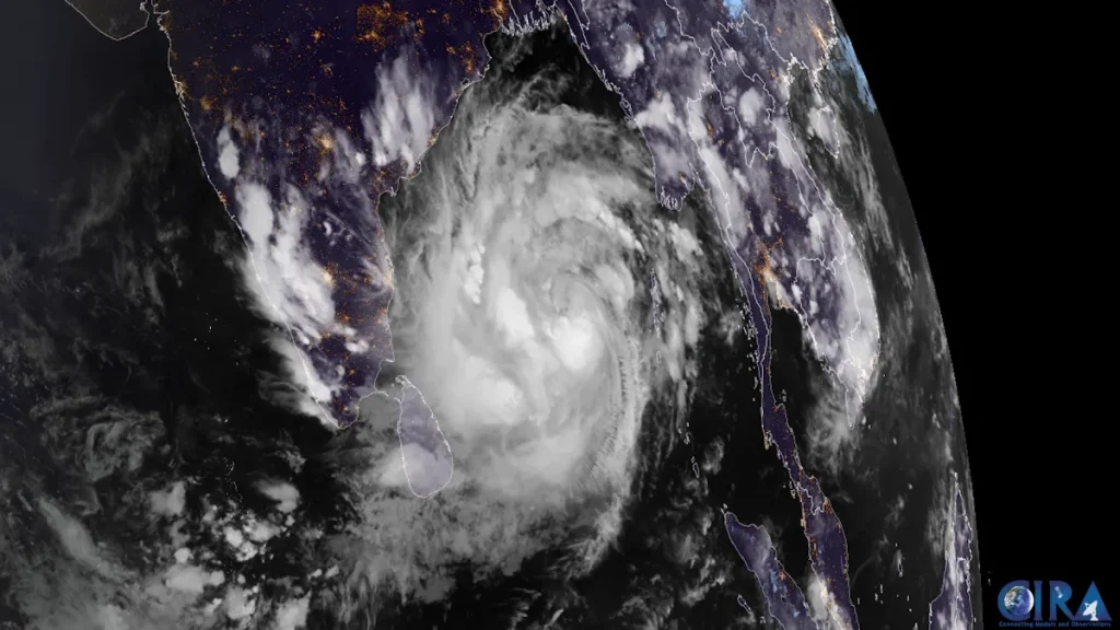
Photo: Meteosat imagery: CSU/CIRA & EUMETSAT / Public domain, via Wikimedia Commons
Not directly. Cyclone Murasu is forecast to cross the south Andhra Pradesh coast between Nellore and Narsapur on the night of 2 to 3 November 2026, far from Pune. The India Meteorological Department (IMD) does not expect cyclone-force winds or heavy rain in Pune, but it has forecast isolated thunderstorms, lightning and gusty winds over parts of Maharashtra, including Madhya Maharashtra, until about 4 November.
Here is what the forecast means for Pune and the rest of the state, and how to read the warnings that will keep coming over the next few days.
In this guide
Where is Cyclone Murasu now and where will it hit?
Murasu formed from a deep depression over the south-west Bay of Bengal and was named a cyclonic storm on 1 November. According to IMD, at 11.30 am on 1 November it was about 560 km east-south-east of Chennai and about 630 km east-south-east of Nellore, moving west-north-west.
IMD’s forecast, as reported on 1 November:
- It was expected to intensify into a severe cyclonic storm by the morning of 2 November.
- It is likely to cross the south Andhra Pradesh coast between Nellore and Narsapur between about 11.30 pm on 2 November and 4 am on 3 November.
- Sustained winds at landfall are forecast at 100 to 110 km/h, gusting to 120 km/h.
Murasu comes barely a week after Cyclone Arnab hit the same coast, so coastal Andhra Pradesh and Rayalaseema are on alert for heavy to extremely heavy rain.
Will Cyclone Murasu bring rain to Pune?
IMD’s city forecast for Pune (Shivajinagar), issued before the cyclone strengthened, showed mainly clear skies with no rain from 1 to 6 November, with maximum temperatures around 31 to 32°C and unusually warm nights of 23 to 24°C.
At the same time, IMD’s regional outlook mentions isolated thunderstorms with lightning and gusty winds of 40 to 50 km/h, gusting to 60 km/h, over Madhya Maharashtra between 1 and 4 November. In plain terms:
- A widespread rainy spell in Pune city is not expected.
- An isolated evening thunderstorm somewhere in Pune district or the ghats cannot be ruled out.
- Cloud cover from the system may keep nights warmer than normal, which delays the start of Pune’s winter chill.
Which parts of Maharashtra may get rain?
According to IMD forecasts reported on 1 November:
| Region | What to expect |
|---|---|
| Konkan and Goa | Isolated thunderstorms, lightning and gusty winds on 2 and 3 November; isolated to scattered rain until about 5 November |
| Madhya Maharashtra (including Pune, Satara, Kolhapur, Nashik) | Isolated thunderstorms and gusty winds on 1 to 4 November |
| Marathwada | Isolated thunderstorms on 3 November; scattered light rain possible until about 5 November |
| Vidarbha | Some influence possible as the remnant of the system moves inland; follow IMD Nagpur bulletins |
Outside Maharashtra, the heaviest rain is expected over coastal Andhra Pradesh, Rayalaseema, Telangana and north Tamil Nadu on 2 and 3 November, with heavy rain later spreading to Chhattisgarh and south Odisha.
Why do Bay of Bengal cyclones sometimes bring rain to Pune?
Pune is on the Deccan plateau, hundreds of kilometres from the east coast, so it never takes the direct hit of a Bay of Bengal cyclone. But when a cyclone crosses the Andhra coast and its remnant moves west or north-west as a depression or low-pressure area, it can pull moisture across the Deccan. That is why some past post-monsoon cyclones brought cloudy days and unseasonal showers to Pune, while others passed with almost no effect.
Whether Murasu’s remnant does this depends on the track it takes after landfall, which IMD will update in its bulletins over the next 48 hours.
What should Pune residents do?
- Follow IMD’s district warnings for Pune, not national headlines. The colour-coded nowcasts on IMD’s website and the Mausam app are the most reliable guide for the next few hours.
- Avoid open grounds and tall trees during a thunderstorm, and unplug sensitive electronics if lightning is close.
- Check travel plans if you are heading to Andhra Pradesh, Telangana or Tamil Nadu. Flights and trains to Chennai, Tirupati, Nellore, Vijayawada and Visakhapatnam may be disrupted on 2 and 3 November.
- Diwali shoppers can carry an umbrella in the evenings as a precaution, but most days this week are expected to stay dry in Pune.
For the latest city forecast, read our Pune weather report for this week. Our earlier coverage of Cyclone Arnab and the new low-pressure system explains how this system developed. We will update this article as IMD issues new bulletins.
Frequently asked questions
When will Cyclone Murasu make landfall?
IMD expects Murasu to cross the south Andhra Pradesh coast between Nellore and Narsapur between about 11.30 pm on 2 November and 4 am on 3 November 2026, as a severe cyclonic storm.
Will Cyclone Murasu bring rain to Maharashtra?
IMD has forecast isolated thunderstorms, lightning and gusty winds over Konkan, Madhya Maharashtra and Marathwada between 1 and 5 November. Heavy, widespread rain is not expected in Maharashtra.
Will it rain in Pune because of Cyclone Murasu?
Pune city is not expected to get widespread rain. IMD’s city forecast shows mainly clear skies, though an isolated thunderstorm in the district cannot be ruled out until about 4 November.
Which states will be most affected by Cyclone Murasu?
Coastal Andhra Pradesh and Rayalaseema are expected to be hit hardest, with heavy to very heavy rain also likely over Telangana and north Tamil Nadu, and later Chhattisgarh and south Odisha.